stories
Mui Wo Bike Park, or in its official name, Mui Wo Practice Ground, South Lantau officially opens on the 17th Dec 2022. It’s time to write down some of these short stories from the years leading up to the completion of this bike park.
We will be posting in parts and as informal as it goes ..
~ HM
List of Press Release relating to the opening ceremony.
back story
My involvement with this bike park dated back to Sept 2009, when officials from Civil Engineering and Development Department (CEDD) and Agriculture, Fisheries and Conservation Department (AFCD) made a study visit to Singapore to check out the various mountain biking facilities. We impressed everyone with our classic pre-Youth Olympics Games, Tampines Bike Park and with the great back country experience offered by Ketam Mountain Bike Park, a trail system that’s unique in a way that’s similar to the Mui Wo experience, a boat ride away from urban city center.
The visit was a success, where the experience, on top of many other visits, got recorded into the South Lantau Mountain Biking Trail Network feasibility study. This document, a massive 5000+ pages of text/drawings/maps, forms the cornerstone of the mountain biking network at South Lantau, which we still reference this document from time to time in 2022!
the design stage
Planning, resource appropriation, and stakeholder engagements took years; perhaps that’s another story for another time. In short, we got busy with bike park again around the late summer of 2016, when the design phase kicks in.
We spent some weeks reviewing the documents we have in hand from the 2008-2011 feasibility study, as by then it’s dated in some ways and we are fortunate to be able to get some of the technical specifications and details updated, to cater to the current and foreseeable future trend of mountain biking in Hong Kong and the region.
I recall our first ‘boots on ground’ trip to the site, a wet 6th Sept 2016 morning. The old burrow site at Lai Chi Yuen Tsuen is just an overgrown service path, with gulley stringing along the length, abruptly ending at the WSD water tank. The area around is dotted with various shrublands and secondary forests where various non-native species are predominant. Concrete drains, and structures randomly scattered around these shrublands, i.e. we will be working on rejuvenating this plot of land in a way.
The current East Entrance of the bike park near Mui Wo helipad feels more like an illegal dumping ground for various machinery, jumbo jets tires, wheel hubs, and various floatables washed up during the annual typhoon.
These plots of land would typically not be associated with back country mountain biking; we would be working with what we have, a challenge. On the positive note, we will be working with rocks and boulders, in which the hillside along the coastline are not short of.
These early Sept 2016 weeks were spent mainly at Quarry Bay, where Jacobs China’s main office is situated. To be able to work in person with the rest of the engineering team during this stage is critical, something we would cherish more after going through these covid pandemic years. We were extremely efficient. I love the process, how we iron out various adaptations required for a mountain biking trail to exist in such a burrow site. It’s to note that there’s probably various contradicting rules and guidelines from various departments that one will need to follow, and Hong Kong is not short of these.
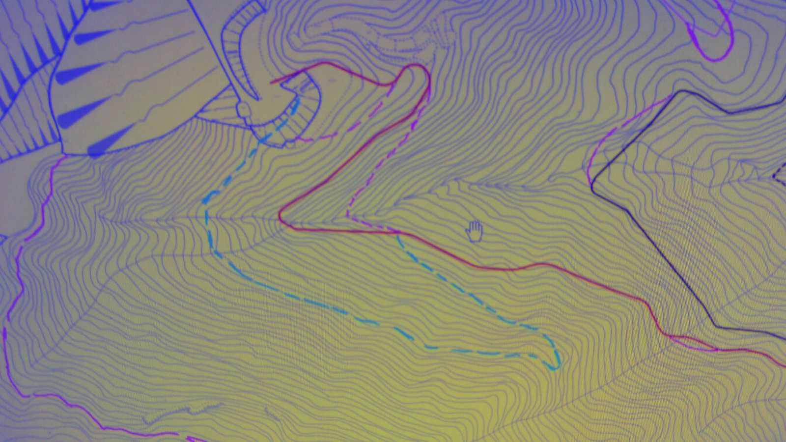
Getting these planning and design work done before any further effort within the tree line is critical. It saved us effort and time. Hong Kong is blessed with a great GIS data feed, where one can easily map the hills with high resolution contours from various LIDAR overflight sources. 2 meters resolution god view stress tested my mobile computing platform, but it allows us to route trails efficiently and these routings are a good 90% of what we ended up building. The overlay allows us to spot rock formations, known gravesites and water features, where we will attempt to avoid. Our ecologist specialist will use a similar dataset to ascertain various ecosystems within and the feedback will be echoed back where we will adjust the master alignment accordingly.


the bushes
On a sunny morning of the 27th Sept 2016, I got my fellow buddy Nick along with 2 guys from the surveyor contractors ready. We started the on-ground trail initial flagging along the coastal shrublands near the helipads. Progress is slow and tedious, where we stride a meter or two every 5 minutes in these thick shrubs. Keeping grades gentle is a discipline in these thick, torn and vine-filled shrubland.
These are typical moments where every trail designer faces, where one might stray away from the design intend, shoot a steeper grade, or be coaxed to route it another way. Therefore, it’s important to have a common understanding among the trail flagging parties on the intended. There’s always valid feedback from members of the party, like a better way to route around a rock, or simply detour for today and do ‘spear flagging’ for the eventual trail routing.
Fatigue do cloud one’s mind in these conditions and it’s great we have to opportunity to space out the work, where we flagged the 2 trails connecting the helipad and Lantau Trail 12, the eventual two connecting trails of Mui Wo Practice Ground, East Entrance.
The following weeks bring us into the various spots along the ‘Climbtrail’ and ‘Savage’. Some memorable lunch break on top of the massive rock outcrop near the top of Savage where we ponder how we bypass this rock while snacking away.
The massive ravine at the top of the ‘Climbtrail’ is another vine and rope adventure, where we have to jump the gap, knowing full well that we will not be routing the trail through this area and the few hundred of meters before this eventually. GIS data does help to a large extend, but this is the perfect example of such limitations on overflight data and technology at the moment, where narrow ravine and undercut are hidden from the eyes of the sky.
data collation
Field collected data provides a whole different perspective of what we can expect of the eventual completed trail.
One can feel the quality of the dirt, the texture of the rock, get a feel of the scenic viewpoint, the breeze, and smell of the flora around it. Basically, the things that made us want to ride such a trail, the human factor.
Noting down such items during the ground survey is part of the chore, where one will need to balance the engineering aspect and artsy aspect at the same time. These data are then translated into the GIS platform, where most of these subjective evaluations end up in design side notes and rarely features in engineering drawings.
By clocking further hours in Quarry Bay, we tweaked the design in the hope of achieving the trail as intended, and to keep issues to the minimal during the construction phase.
It’s to note that, at this point, trees are getting tagged as part of the tree survey exercise and so are the various ecological surveys.
We love trees. Without the shrubland and trees, the trail will not be what it is, and just bare desert, not part of the desirable experience most of the time. In a good way, the tree survey is a good check and balance exercise of properly preserving some of these user experiences.
Most trees are retained, trails meander around them and rarely have to confront the trees directly. However, there’s always some unavoidable circumstances a tree has to go for the safety of the trail user, and we are glad to be able to be choosy. There’s always a rotten trunk or some less desirable species around.
The few weeks of design work continues, and we are relatively confident of the various segments and components of the bike park and its surrounding trails. Trails like the ‘Snake’ and ‘Italy’ are scheduled for further ground survey the next spring, while the rest of the bike park starts to take shape in various design drawings, maps and cut sections.


keeping the conversation open
In early December 2016, we were pretty much ready to get the design intent out to the various stakeholders.
Yes, we do have many interested parties, beyond mountain bikers and user groups. The typical list of stakeholder includes various regulatory bodies, where various comments continue bouncing back and forth for months to come.
The official public relations announcement happens on a chilly morning of 20th Dec 2016. Hong Kong Mountain Bike Association (HKMBA), Cycling Association Hong Kong (CAHK), the village rural committee members and the press are invited by CEDD.
It’s a simple outdoor brief, show-and-tell at Chi Ma Wan trailhead, the first public showcase of the bike park beyond the design and engineering team. I am glad what we’ve presented then was largely intact by the time it’s completed in 2022.
As a mountain biking trail project, and as a fellow mountain biker, I would want to hear from as many bikers as possible. Given the wide array of users out there of various stages of biking experience, comments and feedback will definitely contradict each other. The balancing act of getting something for everyone will never be easy, but we will give it a try.
Countless informal brief followed over coffee, across dinner napkins, over beer coasters, where we bounced fresh ideas back and forth. We debated on the sizing of the jumps, and how ridiculous we want the drop-off to be, and it’s never going to be enough most of the time. The desire for more trails and variety are within the blood of every user, the feature wish list increases over time, fortunately within the design parameters and area.
These were instrumental in the next phase of detail design that followed in the early months of 2017.
part ii to follow..